Hamilton County Extended
The next act
in the work of dividing the Territory into counties, was
changing the boundaries of the counties of Hamilton, Wayne, and
Knox. In 1795, General Wayne had made a treaty with the Indians,
at Greenville, by which the line of the lands of the United
States had been extended from Loramie's, westward to Fort
Recovery, and thence southward to the mouth of the Kentucky
River. The boundary of Hamilton County was extended westward,
June 22, 1798, to make it correspond with this change in the
boundary of the government territory. The line between Hamilton
and Knox counties then became:
"The western
boundary of the county of Hamilton shall begin at the spot, on
the bank of the Ohio River, where the general boundary line of
the United States and the Indian tribes, established at
Greenville the third day of August, 1795, intersects the bank of
that river, and run with that general boundary line to Fort
Recovery, and from thence by a line to be drawn due north from
Fort Recovery, until it intersects the southern boundary line of
the county of Wayne, and from thence to the southern boundary of
the county of Wayne, shall also be the eastern boundary of the
county of Knox."
Hamilton
County in this way got a part of Knox County, and a part of what
is now Indiana.
Ross County
Ross next came into the family of Ohio
counties. Nathaniel Massie, a surveyor in the employ of
Virginia, had laid out the town of Manchester, in 1790, and
induced people to emigrate to it. Massie had become a large land
owner, and circulated glowing descriptions of the country along
the Scioto, with the hope of inducing settlements. Robert J.
Finley, and a Presbyterian congregation from Kentucky, were
attracted, and a settlement was made at the mouth of Paint
creek. Chillicothe was laid out in August, 1796, by Col. Massie.
The opening of Zane's Trace, soon afterwards, diverted much of
the westward travel, which before this time had been in boats
down the Ohio, and brought it overland through this region.
Other settlements sprung up, and with the increase in settlers,
demands were put forward for a division of Adams County. St.,
Clair recognized the need of the new county, and, August 20,
1798, issued a proclamation for it, in which the boundaries were
fixed as follows:
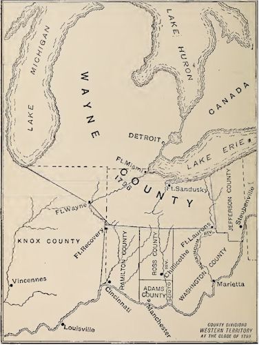
How Ohio Counties Appeared at
the Close of the Eighteenth Century.
''Beginning
at the forty-second mile tree, on the line of the original grant
of land by the United States to the Ohio company * * * and
running from thence west until it shall intersect a line to be
drawn due north from the mouth of Elk River (commonly called
Eagle creek), and from the point of intersection running north,
to the south boundary of the county of Wayne, and from thence
easterly with the said boundary of Wayne, until a north line to
be drawn from the place of beginning, shall intersect the same;
and if it should be found that a north line to be drawn from the
place of beginning, will not intersect the said southern
boundary of Wayne, then an east line is to be drawn from the
eastern termination of the said boundary, until it shall
intersect the aforesaid north line to be drawn from the place of
beginning."
Among the
early settlers in this region were a number from Pennsylvania,
among whom were, Dr. Edward Tifftn who afterwards became the
first governor of the state, and Mr. Thomas Worthington, who
became governor of the state and United States Senator. The
county received its name from Hon. James Hoss, of Allegheny
County. Pa., who was at that time the unsuccessful candidate of
the Federal party for the office of governor of that state. St.
Clair was an ardent Federalist, and had been a member of
Congress from Pennsylvania. Chillicothe was made the seat of
justice. In 1800 it became the capital of the Northwest
Territory. The sessions of the territorial legislature were held
there, in 1801, and the convention which framed the first
constitution of Ohio met there, in 1802. It was the state
capital from that time until 1816, except during the years
1810-1812. August 20, 1798, a strip was taken off the east side
of Hamilton County, and added to Adams. The west line of Adams
was made to commence on the Ohio, at the mouth of Eagle creek,
and run due north until it intersected the southern boundary of
Ross, instead of following up the river to its head, as in the
original boundaries.
Online Resources
|
Ohio AHGP

Source: Ohio Archaeological and
Historical Publications, Volume 5, John L. Trauger, 1898.
|