Hamilton County Enlarged
St. Clair County
The next
county to be set off, was that of St. Clair, in that part of the
territory now included in Illinois. It was proclaimed April 27,
1797, and was bounded as follows:
"Beginning at the mouth of the little
Michilmacinack River, running thence southerly in a direct line
to the mouth of the little river above Fort Massac, on the Ohio
River; thence with the Ohio to its junction with the
Mississippi; thence up the Mississippi to the mouth of the
Illinois River, and so up the Illinois River to the place of
beginning."
St. Clair
divided the county bearing his name into three judicial
districts, viz: Cahokia, Prairie du Rocher, and Kaskaskia, in
which terms of court were to be held the same as if they were
separate counties.
Knox County
On the 20th
of June, 1790, St. Clair set off the county of Knox, most of
which is now in the state of Indiana, with boundaries as
follows:
"Beginning at
the standing stone forks of the Great Miami River and down the
said river to the confluence with the Ohio River, thence with
the Ohio to the small stream or rivulet above Fort Massac;
thence with the eastern boundary line of St. Clair County to the
mouth of Little Michilmacinack ; thence up the Illinois River to
the forks or confluence of the Theokiki and Chicago; thence by a
line to be drawn due north to the boundary line of the territory
of the United States, and so far easterly upon said boundary
line as that a due south line may be drawn to the place of
beginning."
Hamilton County Enlarged
February 11, 1792, St. Clair issued a
proclamation, setting forth the new county provision of the
Ordinance of 1787, by which it was provided that new counties
should be laid out as fast as the Indian titles were
extinguished. There was a portion of the Territory lying between
the Scioto and the Little Miami, which had not yet been included
in a county. This, he said, on account of the scattered nature
of the settlements, did not justify the erection of a new
county, and he added it to the county of Hamilton. The
boundaries of this county were then as follows:
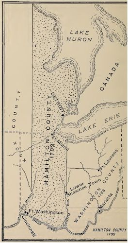
Hamilton County after being
Enlarged
"Beginning at the confluence of the
Scioto with the Ohio River, and up the Scioto with the courses
thereof to the upper art of the old lower Shawnee town upon said
river; thence by and with a line to be drawn due north to the
territorial boundary line, and westerly along said boundary line
to the eastern boundary of the county of Knox, and down along
the said eastern boundary of Knox County by a due south line to
the standing stone forks of the Great Miami River, and with the
said Miami to its confluence of the Ohio River; thence up the
Ohio River to its place of beginning."
Online Resources
|
Ohio AHGP

Source: Ohio Archaeological and
Historical Publications, Volume 5, John L. Trauger, 1898.
|