Randolph and Wayne Counties
Randolph County
On the 15th day of October, 1795, St.
Clair issued a proclamation reciting that the separation of the
county of St. Clair into districts had not given that ease and
facility to the administration of justice which was expected,
and it became necessary that it be divided, and a new county
erected. The territory south of a line running due east from
what was known as the Cove Spring, to the Knox County line, was
made the county of Randolph.
Wayne County
There was a
wide stretch of country on the north part of the Territory that
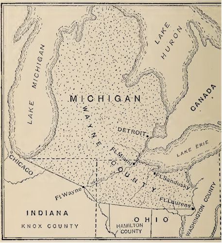
was yet outside of any of the organized counties. On the 15th
day of August, 1796, Wayne County was organized, with boundaries
as follows:
"Beginning at
the mouth of Cuyahoga River, upon Lake Erie, and with the said
river to the portage, between it and the Tuscarawas branch of
the Muskingum; thence down the said branch to the forks, at the
carrying place above Fort Lawrence (Laurens); thence by a west
line, to the eastern boundary of Hamilton county, (which is a
due north line from the lower Shawnee town upon the Scioto
river) ; thence by a line west-northerly to the southern part of
the portage, between the Miamis of the Ohio and the St. Marys
River; thence by a line also west-northerly, to the southwestern
part of the portage, between the Wabash and the Miamis of Lake
Erie, where Fort Wayne now stands; thence by a line
west-northerly, to the most southern part of Lake Michigan;
thence along the western shores of the same, to the northwest
part thereof, (including the lands upon the streams emptying
into said lake); thence by a due north line to the territorial
boundary in Lake Superior, and through the said boundary through
lakes Huron, Sinclair, and Erie, to the mouth of the Cuyahoga
River, the place of beginning."
This, as will
be seen, cut off the northern portion of the counties of Knox
and Hamilton. The Northwest Territory was not divided into the
six counties of Washington, Hamilton, Knox, St. Clair, Randolph
and Wayne.

Map Showing the Original Wayne County.
Online Resources
|
Ohio AHGP

Source: Ohio Archaeological and
Historical Publications, Volume 5, John L. Trauger, 1898.
|
![]()

![]()
