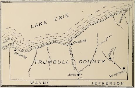
Trumbull County
At the time
of the organization of the Northwest Territory the state of
Connecticut had laid claim to that part of it lying north of the
forty-first parallel of north latitude. In 1786 the legislature
of that state ceded all of this claim to the United States,
except a strip 120 miles in length lying next west of the
Pennsylvania line. This became known as the Western Reserve of
Connecticut, and was often called New Connecticut, as that state
continued to enact laws for its government, and exercise
jurisdiction within it, as she did at home. In May, 1800, her
legislature renounced jurisdiction to this Reserve, and conveyed
the same to the United States. It then became in order for St.
Clair, the territorial governor, to create a county government
for it. Before this, it had been parts of the counties of
Jefferson and Wayne. July 10, 1800, St. Clair placed all of the
Reserve into the county of Trumbull. The new county embraced all
of the territory north of the forty-first parallel, lying within
a distance of 120 miles west of the Pennsylvania line. It was
named in honor of Governor Trumbull of Connecticut, who was the
executive of that state at the time the cession was made. The
county seat was located at Warren.

Original Trumbull County
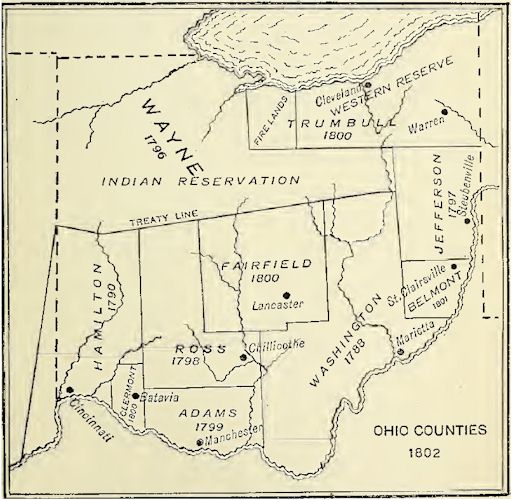
Clermont County
The next
county which St. Clair organized was Clermont. The date of his
proclamation for the purpose was December 6, 1800. It was taken
from the county of Hamilton. The county seat was located at
Batavia. The origin of the name of the county has not been
preserved, but the presumption is that it was derived from
Clermont in France.
Fairfield County
December 9, 1800, but three days after
the organization of Clermont County, St. Clair issued a
proclamation for the organization of Fairfield County. It was
taken from the counties of Washington and Ross, about one-half
from each. St. Clair gave it the name of Fairfield, from the
beauty of its fair lands. The county seat was located at
Lancaster.
Belmont County
Belmont County was formed by St. Clair,
September 7, 1801. It was made up of the northern part of
Washington and the southern part of Jefferson County. Belmont is
derived from two French words signifying a fine mountain. The
surface is very hilly and the land very picturesque. St.
Clairsville, the county seat, derives its name from Governor St.
Clair.
This was the
last county to be formed by the proclamation of the territorial
governor. Subsequent to this, under the new state government,
counties were formed, and their boundaries changed, by act of
the state legislature.

State Formed
This
completes the evolution of Ohio counties to the time the state
was formed. The Convention which met November 1, 1802, to frame
the first state constitution was composed of thirty-five
members, apportioned to the counties appearing on the above map,
as follows: Adams, three Belmont two, Clermont two, Fairfield
two, Hamilton ten, Jefferson five, Ross five, Trumbull two, and
Washington four. The northwestern part of the state, by the
treaty of Greenville, August 3, 1795, had been allotted to the
Indian tribes, as a reservation, and was unsettled by the
Whites. The seat of government of the county of. Wayne was at
Detroit, and when Ohio was being formed, as the greater part of
that county would be in the Indian Territory, it was given no
representation in the convention.
These
counties have been divided and disintegrated, until from the
nine organized counties and the Indian reservation that came to
the state when formed, the number has grown to eighty-eight.
When this article was begun it was the intention to go to the
end, and thus evolve the present county map of the state, but
the time allotted has been too brief to allow it, and we stop at
this convenient point, hoping to be able to present the others
in some subsequent report.
Online Resources
|
Ohio AHGP

Source: Ohio Archaeological and
Historical Publications, Volume 5, John L. Trauger, 1898.
|
![]()

![]()
